
A low-lying cloud layer brought autumn ambience to western Washington and Oregon, while mountainous areas near the coast remained above the pall.
Earth Observatory- Science
- Earth Observatory
- Cloudy Cloak Over the Northwest
- Earth
- Earth Observatory
- Image of the Day
- EO Explorer
- Topics
- More Content
- About
- Search
 September 19, 2026
NASA Earth Observatory/Michala Garrison
September 19, 2026
NASA Earth Observatory/Michala Garrison
Cool, marine air rolling off the Pacific Ocean led to a picturesque layer of morning clouds over western Washington and Oregon in mid-September 2026. Low-lying stratus clouds and fog extended as far inland as the western foothills of the Cascade Range. Near the coast, taller portions of the Olympic Mountains in Washington and the Oregon Coast Range appeared island-like, protruding above the cloud layer.
The MODIS (Moderate Resolution Imaging Spectroradiometer) on NASA’s Terra satellite shows the extent of the Pacific Northwest’s cloudy cloak on September 19, 2026, at about 10:45 a.m. Pacific Time (17:45 Universal Time). Abundant clouds also appear offshore over the Pacific, while smoke from wildland fires fills valleys in the North Cascades.
For several nights in a row, marine air flowed onshore, according to the National Weather Service, bringing with it low-level clouds known as marine stratus. These clouds form when moist air near the surface, trapped beneath a warmer air layer in a temperature inversion, cools enough for its water vapor to condense. The surge of cool, moist conditions was particularly strong early on September 19, producing cloudy conditions all the way up to the Cascade foothills. Some areas witnessed foggy conditions, where clouds extended down to the ground.
That same day, when NASA’s Aqua satellite passed over the area at about 4:15 p.m. Pacific Time (23:15 Universal Time), skies had cleared over much of the area. However, some marine clouds still clung to the Oregon coast, where temperatures stayed cooler than inland locations.
NASA Earth Observatory image by Michala Garrison, using MODIS data from NASA EOSDIS LANCE and GIBS/Worldview. Story by Lindsey Doermann.
Downloads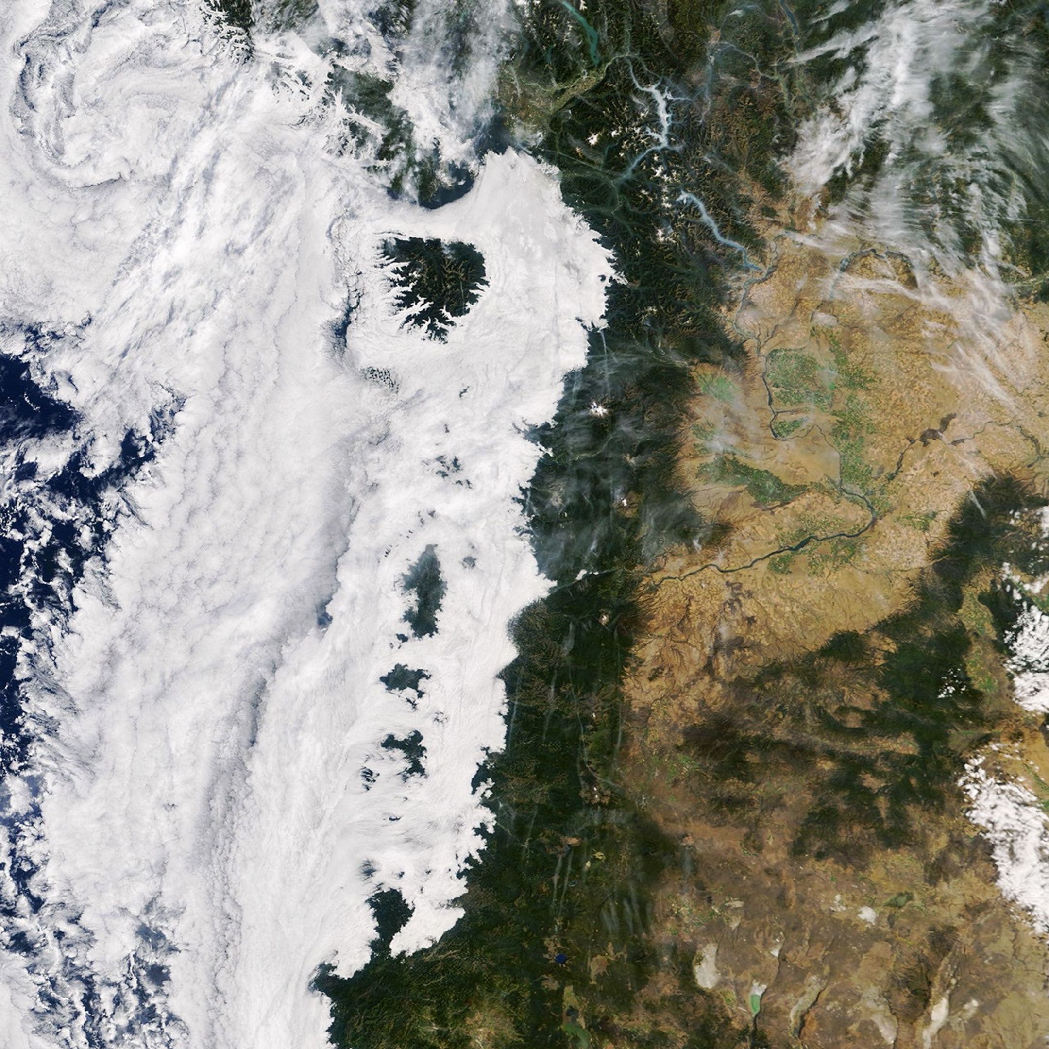 September 19, 2026
JPEG (3.26 MB)
References & Resources
- Dye, A. W., et al. (2020). Spatial patterns and trends of summertime low cloudiness for the Pacific Northwest, 1996–2017. Geophysical Research Letters, 47, e2020GL088121.
- EUMeTrain, Fog and Stratus. Accessed September 23, 2026.
- NASA Earth Observatory (2016, December 20) A Celebration of Clouds From Space, Earth Has an Elegant Atmosphere. Accessed September 23, 2026.
- National Weather Service, What are Marine Layer Clouds and How Do they Form? Accessed September 23, 2026.
- National Weather Service Portland, OR (2026, September 23) Area Forecast Discussion. Accessed September 23, 2026.
- National Weather Service Seattle WA (2026, September 23) Area Forecast Discussion. Accessed September 23, 2026.
Stay up-to-date with the latest content from NASA as we explore the universe and discover more about our home planet.
El Niño Is Underway
4 min read
Satellite observations of sea surface height indicated that the 2026 event continued to strengthen in early June.
Article
El Niño Alters Marine Life in the Pacific
5 min read
Satellite measurements of chlorophyll at the sea surface signal shifts in the ocean’s nutrient supplies in mid-2026.
Article
Olympic Mountain Glory
4 min read
Snow-capped mountains carved by deep river valleys preside over northwestern Washington state.
Article1
2
3
4
Next
Keep Exploring Discover More from NASA Earth Science Subscribe to Earth Observatory Newsletters
Subscribe to the Earth Observatory and get the Earth in your inbox.

Earth Observatory Image of the Day
NASA’s Earth Observatory brings you the Earth, every day, with in-depth stories and stunning imagery.

Explore Earth Science

Earth Science Data
Open access to NASA’s archive of Earth science data

Advertisement
Stats
- Recommendations n/a n/a positive of 0 vote(s)
- Views 6
- Comments 0